Tatakoto Atoll FP

Wednesday, December 27, 2006

Tatakoto Atoll FP

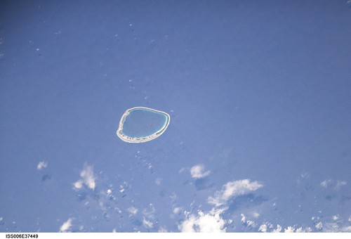
Tatakoto (17˚20'S., 138˚25'W.) is a low atoll about 90 miles NW of Pukaruha that is wooded on the NW part. The lagoon is inaccessible from the sea, but a landing may be made near a flagstaff in a village on the atoll's W side.  (SD Pub-126)


TATAKOTO
THE TUAMOTU ARCHIPELAGO

Other names given by European discoverers: Augier, Narcisse

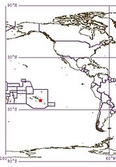
Tatakoto is located 1,182 kilometers (724 miles) from the island of Tahiti and some 180 kilometers (119 miles) from the nearest inhabited atolls of Vahitahi and Puka Puka; Tatakoto is undoubtedly one of the most remote atolls in the Tuamotu Archipelago as well as all of French Polynesia.

Geography

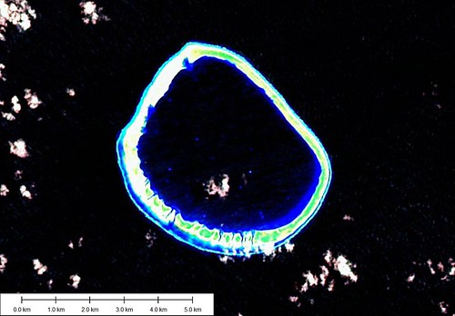
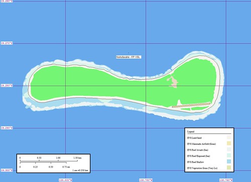
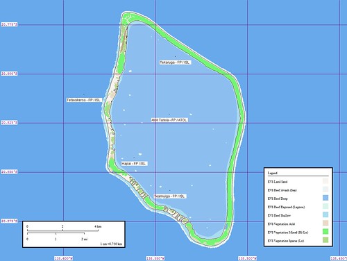
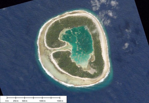
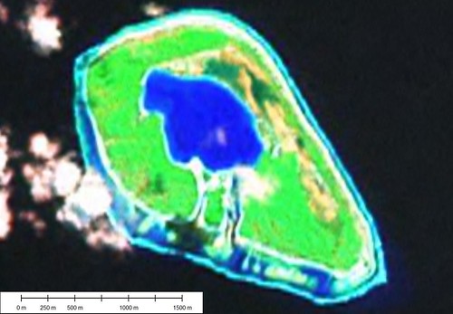
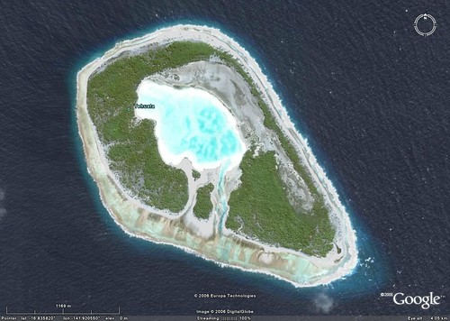
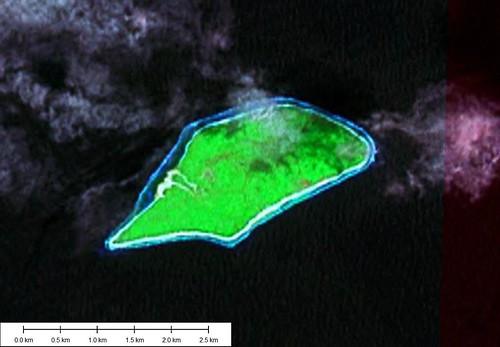
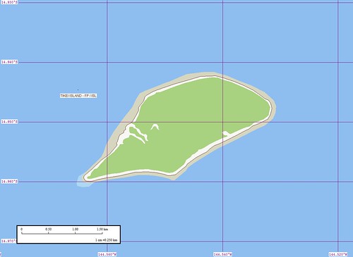
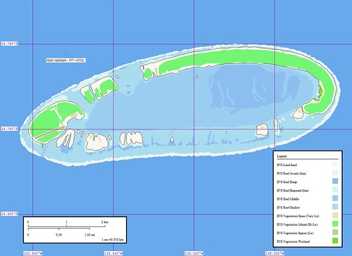
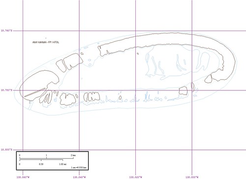
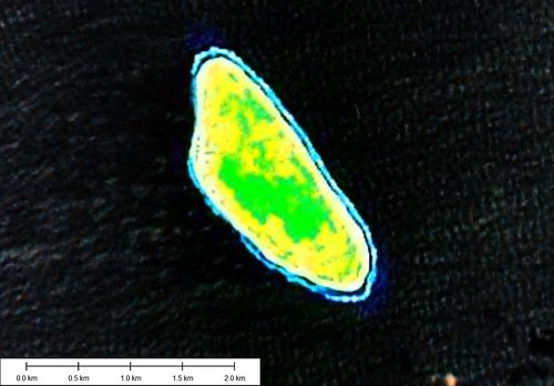
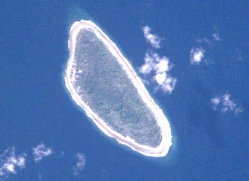
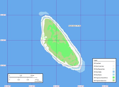
This bean-shaped atoll is 14 kilometers (8.7 miles) long and 3.5 kilometers (2.2 miles) wide. It is located at 17°20’ south latitude and 138°24’ west longitude.
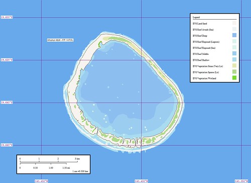
Tatakoto covers an area of 730 hectares (1,804 acres) divided up into 65 islets, or motu. Its lagoon, which covers an area of 1,970 hectares (4,868 acres), is 11 kilometers (6.8 miles) long and 2.5 kilometers (1.6 miles) wide. The biggest motu is 15 kilometers (9.3 miles) long and 400 meters (1,312 ft.) wide, covering the entire north coast of the atoll in an east-west direction. The southern side of the atoll is exposed to prevailing winds and is composed of a series of motu separated by small passes. The biggest motu has an unpaved runway that is practical for flying out copra. The village of Tumukuru is concentrated on both sides of the main road and along the coconut plantation road, an overall area measuring 600 meters (1,969 ft.) long by 200 meters (656 ft.) wide. Six main streets crisscross the village of Tumukuru, which is located on the western point of the atoll. Tatakoto has an aerodrome located near the village, but the atoll does not have a pass through the coral reef enclosing the lagoon. The village has a whaleboat dock and a 25-meter (82-ft.) pier. A second whaleboat dock is located in the southern part of the atoll.

History

Two Spanish explorers—Domingo de Boenechea and Andiay Varela—sighted Tatakoto independently of each other on the same day in 1774, becoming the atoll’s first European discoverers. From 1900 to 1927 Frenchman Albert Javelot served as the atoll’s chief, planting the atoll with coconut trees that still cover the atoll today. The 1996 census recorded a population of 247 persons.

(From Presidency of French Polynesia Web Site)


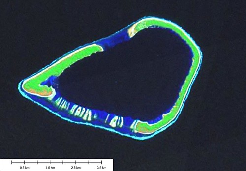
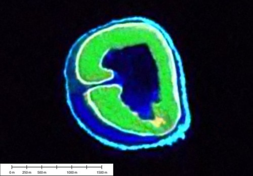
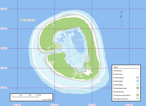
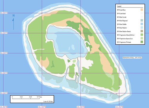
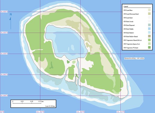
Atolls are both satisfying and frustrating to map.  They take hours to complete.  This atoll consists of 13 identified layers and another 4 additional layers.  Each layer of information requires consistent identification and delineation.  Each atoll's EVS Reef Middle, for example, should be consistently identified from the Landsat mosaics used as base imagery no matter the island.  The steps to create a map such as this are both tedious and demanding.  Now for the good stuff - the finished map looks great!  It not only looks great, it is a solid cartographic effort.  Even before I began this project, I knew that ultimately the finished product would look great.  The base imagery is clean and provides a crisp picture of the atoll.  The challenge was to keep working.  And that is just what I did.

Enjoy! 

Labels: , , , , , , , , ,

posted by Mr Minton at 11:26 AM 1 comments

Ahunui Atoll FP

Anunui Atoll - Image

Ahunui Atoll - Landsat Image S-07-15_2000 (1:50,000)


Anunui Atoll - Map

Ahunui Atoll - Marplot Map (1:50,000)


Ahunui Atoll (Ahounoui, Byam Martin, Cockburn)is an uninhabited wooded atoll. The lagoon is in-accessible, but there is a landing place on the NW end of the atoll near some huts and a tank. (SD Pub-126)


Ahunui Atoll - Shuttle Image

Ahunui Atoll - ISS Image ISS006-E-37449


This atoll does not have much information posted on the Internet. The Sailing Directions give very little information. The Shuttle Image shows a vegetation area on the western motu that the Landsat image does not show. The Landsat image appears to be washed out (if that can be possible with satellite imagery).


I spent about four hours digitizing the shoreline of this atoll. It was a fairly simple process.

Enjoy!

Labels: , , , , , , , , ,

posted by Mr Minton at 10:59 AM 0 comments

Nukutavake Island FP

Nukutavake Island - Image

Nukutavake Island - Landsat Image S-07-15_2000


Nukutavake Island - Map

Nukutavake Island - Marplot Map


Nukutavake Island (Noukoutawake) is a small island, of coral formation, located about 8 miles NW of Pinaki. It is about 3 miles long in an E-W direction, and is wooded except at its E end. There is a radio station on the island.

In May, June, and July the population of this atoll moves to Vairaatea, and in August, to Pinaki to harvest copra. (SD Pub-126)


Group: Centre East Group
Archipelago
: Tuamotu Archipelago
Country: France - French Polynesia - Tuamotu Is.
Region
: Oceania 18
Lat: 19.28º S Long : 138.78º W
Area: 4.5 sq. km
Altitude: ? m
Depth to nearest land: 3000 m
Nearest island: 14.5 km @ 143° (Atoll Pinaki)
Group
: 980 km
Nearest continent: South America
Distance
: 5400 km Isolation Index: 108

ISLAND TYPE: low coral Natural Protection Indicator: 2
CLIMATE: tropical
CATASTROPHIC THREATS: cyclones Threat Indicator: 1
ECOSYSTEMS: Coconuts; fringing reef Number of Ecosystems - Terrestrial: 1 Marine: 1
Percent shoreline: Coral Reef: 99% Mangrove: 0%

HUMAN OCCUPATION: Uninhabited, ?
Population: 0 Density: 0.0 persons/sq. km
Major Human Activities: coconut plantations
Percent population in agr/mining/fishing: 17% Human Threat Indicator: 1
Gross Domestic Product: $ 7236 per capita Economic Pressure Indicator: 4

DATA RELIABILITY: Data Rel. Indicator: 1

HUMAN IMPACT INDEX HI: 5
CONSERVATION IMPORTANCE INDEX CI-Terrestrial: 5 Low
CI-Marine: 4 Low

Last updated: 27/02/89


Nukutavake (aka Queen Charlotte Island) is an atoll located in the eastern part of the Tuamotu Archipelago at 138°48’ west longitude by 19°17’ south latitude. It is 1,125 kilometers (699 miles) from Papeete. British Captain Samuel Wallis was the first European to discover this atoll in 1767. This is a unique atoll because although it is flat and of coral formation, it has no lagoon. While some accounts claim there are no signs of there ever having been a lagoon, other accounts claim that what was once a lagoon has been entirely filled in by sand and limestone particles from the external coral reef. Part of the atoll is covered by dense vegetation, while the rest has a coconut tree plantation covering some 800 hectares (1,977 acres). Nukutavake is 5.2 kilometers (3.2 miles) long. Its width ranges from 450 meters (1,476 ft.) to 1.3 kilometers (0.81 miles) in the director of the village. The atoll covers an area of 360 hectares (890 acres).

The village, located in the northeastern part of the atoll, has some streets and a main road from the coast and the coconut plantation. There is an aerodrome 800 meters (2,625 ft.) south of the village, linking the atoll to the outside world. There is a whaleboat dock opposite the village that allows for transferring people and cargo from and to cargo ships that anchor offshore. The 1996 census recorded a population of 196 persons. The atoll is the administrative center for a district made up of the associated districts of Vahitahi and Vairaatea.


This island was mapped quickly. Not carelessly, but quickly. It took about 1-hour to digitize and create the map. Another 30-minutes to post and comment.


Also, the discovery of the additional island information from the web site of the President of French Polynesia (what a job!) will enhance the information associated with this island. I did send him an email to present my website. However, no reply as yet.

Enjoy!

Labels: , , , , , , , , ,

posted by Mr Minton at 10:56 AM 0 comments

Pukaruha Atoll FP

Pukaruha Atoll FP

Pukaruha Atoll is off the beaten path. It lies to at the eastern limits of the Tuamotus. The main motu has a village located at the northern end. Half-way down the main motu is an airstrip.

Now for the real scoop. This is my best map artistically and my most detailed. It has close to 1,000 polygons that makeup the various layers of infornmation. I used Google Earth imagery to construct this map. The imagery is 1-meter resolution and I mapped the hell out of it! The project took about 20 hours.

Frequent visitors know that I primarily work off of Landsat ETM+ 2000 mosaic imagery. This island and it's neighbor are not covered in the available Landsat imagery. I am sure that it was a fluke that this mosaic was not made available to the public. However, I wanted to map it. So I checked out the imagery on GE and found the included base imagery. The lagoon reef is a work of art and it is accurate.

For those of you that just like to see my latest project, this is it. For those of you that appreciate a gorgeous map, this is it as well.

Enjoy!

Labels: , , , , , , , , ,

posted by Mr Minton at 10:55 AM 0 comments

Akiaki Island FP

Akiaki Island - Image

Akiaki Atoll - Landsat Image S-07-15_2000 (1:10,000)


Akiaki Island - Map

Akiaki Atoll - Marplot Map (1:10,000)


Akiaki (Aki Aki, Thrum Cap) [1790] (18˚33'S., 139˚13'W.), NW of Vahitahi, is a small island of coral formation. There is a landing on the NW side that is difficult. (SD Pub-126)


Group: Centre East Group
Archipelago: Tuamotu Archipelago
Country: France - French Polynesia - Tuamotu Is.
Region
: Oceania 18
Lat: 18.56º S Long : 139.21º W
Area: 1.3 sq. km Altitude: ? m
Depth to nearest land: 3000 m
Nearest island: 43.4 km @ 123° (Atoll Vahitahi)
Group
: 940 km
Nearest continent: South America
Distance
: 5500 km Isolation Index: 112

ISLAND TYPE: low coral Natural Protection Indicator: 2
CLIMATE: tropical
CATASTROPHIC THREATS: cyclones Threat Indicator: 1
ECOSYSTEMS: Coconuts, fringing reef Number of Ecosystems - Terrestrial: 1 Marine: 1
Percent shoreline: Coral Reef: 99% Mangrove: 0%

HUMAN OCCUPATION: Uninhabited, visited occasionally
Population: 0
Density
: 0.0 persons/sq. km
Major Human Activities: coconut plantations
Percent population in agr/mining/fishing: 17% Human Threat Indicator: 1
Gross Domestic Product: $ 7236 per capita Economic Pressure Indicator: 4

DATA RELIABILITY: Data Rel. Indicator: 1

HUMAN IMPACT INDEX HI: 5
CONSERVATION IMPORTANCE INDEX CI-Terrestrial: 5 Low
CI-Marine: 4 Low

Last updated: 27/02/89


This small island claims to be an atoll. It is reported to be visited occassionally to work the coconut trees that are planted on it. I believe that the populated island is Vahitahi and these are the people that visit Akiaki. There is still hope for the nomadic lifestyle.

Enjoy!

Labels: , , , , , , , , ,

posted by Mr Minton at 10:46 AM 0 comments

Tureia Atoll FP

Atoll Tureia - Image

Tureia Atoll - Landsat Image S-07-20_2000 (1:75,000)


Atoll Tureia - Map

Tureia Atoll - Marplot Map (1:75,000)


Tureia Atoll (20˚49'S., 138˚32'W.) 7 miles long and 5.5 mile wide, is low and wooded except on the SE side; the lagoon is not accessible. Landing at the village on the N side is dangerous and requires the use of a surf boat. (SD Pub-126)


This small atoll in the southern Tuamotu Archipelago is located at 20°50’ south latitude by 138°33’ west longitude. It covers an area of 8.3 square kilometers (3.2 sq. miles). Tureia Atoll is 115 kilometers (71.5 miles) from the atoll of Moruroa and 1,190 kilometers (739 miles) from Papeete. This diamond-shaped atoll is a maximum length of 13 kilometers (8.1 miles) and a maximum width of 7.4 kilometers (4.6 miles). It covers an area of 4,721 hectares (11,665 acres). There is no pass through the surrounding coral reef. The biggest islet, or motu, is located along the northwest coast and measures 22.5 kilometers (14 miles) long by and 250 meters (820 ft.) wide, running from the east coast to the south coast. There also are 27 small motu along the east coast with a total land area of 835 hectares (2,063 acres).

British Captain Edward Edwards, who was looking for the famous “HMS Bounty” mutineers, was the first European to discover Tureia in 1791. This atoll is the administrative center for a district with a population of 1,321 persons (1996 census). A full meteorological station began operation here since 1967, going automatic within the weather station network in June 1987. The station began measuring rainfall in January 1990, an operation that ended in March 1996 with its closing down.

A road from the village of Hakamaru to the north circles the atoll as far as the south. Other roads provide access to the coconut tree plantation, an aerodrome south of the village and a former Pacific Nuclear Testing Center camp made up of 20 facilities, including shelters and several water tanks, all of which have since been abandoned by the French Army.

Information from Presidency of French Polynesia


This is a redo of a very early effort. My first attempt was completed over 2 years ago. I deleted it as I was developing this version. Using Landsat imagery is great for constructing shoreline details resolved to a certain level (+/- 14.5 meters). However, the determination of type of vetation groundcover is tricky at best. One really needs to personally view the island's flora to make an accurate determination. What a job!

Enjoy!

Labels: , , , , , , , , ,

posted by Mr Minton at 10:43 AM 0 comments

Vairaatea Atoll FP

Atoll Vairaatea - Image

Vairaatea Atoll - Landsat Image S-07-15_2000


Atoll Vairaatea - Map

Vairaatea Atoll - Marplot Map


Vairaatea Atoll (19˚21'S., 139˚13'W.) is comprised of islands joined by a barrier reef surrounding a lagoon. The surf is heavy and landing is difficult; the usual place is near a shed with a flagstaff situated on the NW end of the atoll. There is a village on the atoll's NW.
Vahitahi is an atoll located about 29 miles N of Nukutavake. The lagoon is not accessible from the sea. The shores of Vahitahi are steep-to except the S part, which should not be approached within 0.3 mile. A village lies on the atoll's W end. (SD Pub-126)

I did come across an accout by Moshe Rappaport's visit to Vairaatea Atoll in 1989. At the time of his visit there were a total of eight families living on the island. He spoke of docking at a pier. On the main island (NW tip) is the village. Their looks to be a small harbor and a feature that I called a EVS Reef. Yet it could be a pier. Although there is no reported entrance into the lagoon for larger vessels. One can come ashore in a motor boat or a Zodiac.


Atoll Vairaatea - Outline BW

Vairaatea - Outline BW


I am throwing in an outline map of the island. Any of my digitized layers can be turned off. This keeps the EVS Shoreline and converts the EVS Reefs into blue lines. This is a nice map to work with to plot observations.

I have been working on this project for the past 4-hours. It is late and I am tired. Good nite!

Enjoy!

Labels: , , , , , , , , ,

posted by Mr Minton at 10:32 AM 0 comments

Pinaki Atoll FP

Pinaki Atoll - Landsat Image S-07-15_2000 (1-15,625)

Pinaki Atoll - Landsat Image S-07-15_2000 (1-15,625)


Pinaki Atoll - Shuttle Image ISS-004-E-12986 (1-15,625)

Pinaki Atoll - Shuttle Image ISS-004-E-12986 (1-15,625)


Pinaki Atoll - Marplot Map (1-15,625)

Pinaki Atoll - Marplot Map (1-15,625)

POL - Pinaki Atoll

Pinaki Atoll, according to various sources, is uninhabited. It is visited on occassions by villagers from Nukutavake Island 14-kms to the NW.

My original post containing the Landsat image, which I had used as base imagery, and my Marplot map. At the time, the map was solid at depicting features that were derived from the Landsat image.

Since those early efforts I have discovered other sources of base imagery. Most often, I will use Google Earth imagery. It is typically 1-meter imagery. I will also use Shuttle imagery. Although, it is typically very high quality. However, you have to align and occassionally stretch and skew the imagery.

I used a Shuttle image for my base imagery. I was able to georectify it using four ground control points. The map I was able to produce corrects many Landsat imprecisions.

I typically keep my single island posts simple - orientation map, image and map. This time I am going to include a Flickr slideshow. The Smithsonian has a large collection of archived photos and reports. One of these series of photos are of Pinaki Atoll. They were taken by Charles Townsend Haskins in 1900.


Pinaki Atoll FP - From a 1900 Exploration Trip


Enjoy!

Labels: , , , , , , , , , , , ,

posted by Mr Minton at 10:28 AM 0 comments

Tehuata Atoll FP

Tehuata Atoll - Landsat Image S-07-15_2000 (1-15,625)

Tehuata Atoll - Landsat Image S-07-15_2000 (1:15,625)


Tehuata Atoll - Marplot Map (1-15,625)

Tehuata Atoll - Marplot Map (1:15,625)


POL - Tehuata Atoll

Tehuata Atoll aka Rekareka Atoll is small in comparison to it's neighbors. According to the UN Island Directory entry for Rekareka Atoll the island is uninhabited. Most probably the island is visited to harvest copra. The digitizing was fast and uncomplicated. GE has a 1-meter resolution image available for this island. I might use it later. I did a quick comparison and find that what I mapped is good.


Tehuata Atoll - Google Earth Image (1-15,125)

Tehuata Atoll - Google Earth Image (1-15,125)


Tehuata Atoll - Marplot Map (1-15,125)

Tehuata Atoll - Marplot Map (1-15,125)


Okay, I am a perfectionist. I couldn't leave the map alone. Using the Google Earth 1-meter resolution imagery as base, I checked out my original vectors. A few minor adjustments. The primary change was a layer classification. I renamed EVS Land Gravel Sand, which I used once on Caldey Island UK, to EVS Land Distressed Sand. I believe that the grey sandy portion of the island is salt-water saturated. I like distressed sand instead of water saturated sand. Lots of things can distress sand besides water. And since it is my map, that is what I will continue to call it.


Enjoy!

Labels: , , , , , , , , , , ,

posted by Mr Minton at 10:22 AM 0 comments

Reitoru Atoll FP

Reitoru Atoll FP

Reitoru Atoll (17˚50'S., 143˚06'W.), a low atoll, has no en-trance into the lagoon.

(SD Pub-126)

More information about Reitoru Atoll can be found at an interesting link that gives some facts about the very small population that makes a living from pearling.

This is the finished map with vectors taken from the Google Earth 1-meter resolution image. The map took about four hours to complete. It is a very solid effort.

Enjoy!

Labels: , , , , , , , , , , , ,

posted by Mr Minton at 10:21 AM 0 comments

Taiaro Atoll FP

Taiaro Atoll FP

First some facts about this small atoll. According to a 1994 Franco-Australian Expedition the lagoon contained within is hypersaline (real salty). Yet, it contains "a high diversity of fish". The theory is that high waves push ocean water into the lagoon bringing in zooplankton and other oceanic fish. In another article from this same expedition the zooplankton within the lagoon was found to be different from the zooplankton found in the ocean off-shore. This would seem to confirm that the lagoon is almost completely isolated from the ocean.

Due to it's uniqueness, Taiaro Atoll is part of the Tuamotu Biosphere Reserve. It, along with five other atolls within the Fakarava Municipality makeup this protected area. The above referenced link also contains a few photos from the atoll.

Finally, there is a copy of a report issued by the 1994 Franco-Australian Expedition that gives the curious reader detailed information about the closed life cycle for some coral fish within the Taiaro Lagoon.


This project took about six hours to complete. I elected to digitize using Google Earth/Digital Globe imagery at 1:1-meter. The resulting map is highly detailed and attempts to make accurate on-land layer determinations. The southern end of the atoll was the most challenging. The reef in this area is complex and difficult to determine whether features are above or below water. This is where "local knowledge" would serve to make the best final layer determinations. Perhaps one day I will make that trip to my mapped islands to provide that "local knowledge" my projects require. Until then, this will have to do.

Enjoy!

Labels: , , , , , , , , , , , ,

posted by Mr Minton at 10:18 AM 0 comments

Tikei Island FP

Tikei Island - Landsat Image S-06-10_2000 (1-25,000)

Tikei Island - Landsat Image S-06-10_2000 (1-25,000)

Tikei Island - Marplot Map (1-25,000)

Tikei Island - Marplot Map (1-25,000)

POL - Tikei Island

Tikei Island (14˚58'S., 144˚33'W.) is a small island about 60 miles NE of Aratika. The only landing place is at a small village on the W extremity of the island, and it is difficult. (SD Pub-126)

Tikei Island is a poorly researched island. It is not a typical Tuamotu atoll, but an island. It is a low island that most likely was an atoll many millions of years ago. The lagoon is gone and the island is covered with heavy vegetation.

Enjoy!

Labels: , , , , , , , , , ,

posted by Mr Minton at 9:54 AM 0 comments

Clipperton island FR

Tuesday, December 26, 2006

Clipperton Island - Marplot Map (1-25,000)

Clipperton Island - Marplot Map (1:25,000)


It has been some time since I was able to post a completed island. It seems that Blogger is running a bit on the slow side. Anyway, here goes a new post. Clipperton Island is known as a great sport fishing destination. It is also home to a weird tale about a king and his unwilling court. You can find out about that story at other places on the Internet.

The map was a challenge to create. Using MARPLOT and non-copyright images, I was able to create the map. The Landsat image was very course. In addition, cloud cover obscured parts of the island. Through mapping diligence and keen eyesight, I was able to complete the above project. I think it looks just fine.

Enjoy!

Labels: , , , , , , ,

posted by Mr Minton at 2:19 PM 0 comments

Vahitahi Atoll FP

Atoll Vahitahi - Image

Vahitahi Atoll - Landsat Image S-07-15_2000


Atoll Vahitahi - Map

Vahitahi Atoll - Marplot Map


Vahitahi Atoll (138 50'W 18 35'S) is an atoll located about 29 miles N of Nukutavake. The lagoon is not accessible from the sea. The shores of Vahitahi are steep-to except the S part, which should not be approached within 0.3 mile. A village lies on the atoll's W end. (SD Pub-126)


Vahitahi Atoll is located in the eastern part of the Tuamotu Archipelago, about 50 kilometres to the north of Nukutavake, and historically the most densely settled atoll in the eastern part of the archipelago.

250 hectares in area, Vahitahi is just under 5 kilometres from west and east, and 1½ kilometres from north to south. Apart from its southern side, where there is a low reef, the atoll has little vegetation.

It has a shallow lagoon with coral above sea level in many places and no entrance to the sea. It was this feature of the atoll that led to Cook naming it 'Lagoon Island'.

The first Europeans to see the atoll were the voyagers commanded by Louise-Antoine de Bougainville (1729-1811) in March 1768.

Today the atoll has around 70 inhabitants and is part of the Commune of Nukutavake in the Tuamou-Gambier administrative subdivision of French Polynesia.

http://nla.gov.au/nla.cs-ss-biogs-P000330


Vahitahi [1791]
Group: Centre East Group
Archipelago: Tuamotu Archipelago
Country: France - French Polynesia - Tuamotu Is.
Region
: Oceania 18
Lat: 18.58º S Long : 138.83º W
Area: 0.0 sq. km Altitude: ? m
Depth to nearest land: 3000 m
Nearest island: 45 km group: 980 km
Nearest continent: South America
Distance
: 5400 km Isolation Index: 111

ISLAND TYPE
: atoll Natural Protection Indicator: 2
CLIMATE: tropical
CATASTROPHIC THREATS: cyclones Threat Indicator: 1

ECOSYSTEMS
: Coconuts on west, east bare; windward and leeward atoll reefs and closed lagoon Number of Ecosystems - Terrestrial: 1 Marine: 3
Percent shoreline: Coral Reef: 99% Mangrove: 0%

HUMAN OCCUPATION: Uninhabited, ?
Population: 0
Density: 0.0 persons/sq. km
Major Human Activities: coconut plantations
Percent population in agr/mining/fishing: 17% Human Threat Indicator: 1
Gross Domestic Product: $ 7236 per capita Economic Pressure Indicator: 4

DATA RELIABILITY
: Data Rel. Indicator: 1
HUMAN IMPACT INDEX HI: 5
CONSERVATION IMPORTANCE INDEX CI-Terrestrial: 5 Low
CI-Marine: 5 Moderate

Last updated: 27/02/89


Atoll Vahitahi - Map Outline

Vahitahi Atoll - Marplot Map Outline


And finally, here is an outline map of the island. It also shows the various reefs. My favorite is the outline map. I suspect that the reader would prefer the color map or the image. The outline is the ultimate map. As an end user, I can take it and add my own unique information. In my opinion, it offers the greatest flexibility.

Enjoy!

Labels: , , , , , , , , ,

posted by Mr Minton at 11:54 AM 0 comments

Tepoto Island FP

Tepoto Island FP - Image

Tepoto Island - Landsat Image S-07-10_2000


Tepoto Island FP - ISS002-E-8862

Tepoto Island - ISS Image ISS002-E-8862


Tepoto Island FP - Map

Tepoto Island - Marplot Map


Tepoto Island (14˚03'S., 141˚25'W.) about 10 miles NW of Napuka, is about 18.3m high to the top of the trees; it is the NW island of the Iles du Desappointement. Landing is practicable, with assistance of the natives, on the W side of the island. (SD Pub-126)


From Wikipedia: Tepoto, a coral island, is the northwesternmost of the Disappointment Islands, in the Tuamotu Archipelago, located at 14° 8' S lat and 141° 24' W long. The island is sometimes called Tepoto Nord in French, to avoid confusion with the Tepoto atolls 400 km (240 mi.) to the southwest in the Raeffsky Islands of central Tuamotu. According to the 2002 census, its population was 54 inhabitants. The primary village is Tehekega.


From IRD: Northern Tepoto which is one of the North-Eastern Tuamotu islands, is situated 16°48' south and 144°19' west, 16 km to the north-west of Napuka. This is one of the high atolls, or "makateas", with a dry lagoon: the solid ground thus forms an island 2.6 km long and 800 m wide. Tepoto. is surrounded by a barrier reef. There is a road 5m wide running round the whole atoll. The village of Tehekega in the nord-west of the atoll can be reached by taking one of the whale-boats which call in at a jetty 28 m long and 4.5 m wide. This atoll has an area of 400 hectares.

Northern Tepoto, which was discovered by John Byron in 1765, has had very few contacts with the Western world. In 1988, the population of the island consisted of only 62 inhabitants (there were 67 in 1983).

Northern Tepoto belongs to the commune of Napuka


From UNEP: Tepoto Nord [1761]
Group: Centre West Group
Archipelago: Tuamotu Archipelago
Country: France - French Polynesia - Tuamotu Is.
Region
: Oceania 18
Lat: 14.º S Long : 141.33º W
Area: 2.05 sq. km
Altitude: 18.3 m (to tree tops)
Depth to nearest land: 3000 m
Nearest island: 16.5 km (110º) Napuka
Group
: 420 km
Nearest continent: South America
Distance: 6100 km Isolation Index: 102

ISLAND TYPE
: atoll Natural Protection Indicator: 2
CLIMATE: wet tropical
CATASTROPHIC THREATS: cyclones Threat Indicator: 1
ECOSYSTEMS: Windward and leeward atoll reefs, open lagoon Number of Ecosystems - Terrestrial: 1 Marine: 3
Percent shoreline: Coral Reef: 99% Mangrove: 0%

HUMAN OCCUPATION
: Inhabited
Population: 54 (2002 Census)
Density: 26.3 persons/sq. km
Percent population in agr/mining/fishing: 17% Human Threat Indicator: 1
Gross Domestic Product: $ 7236 per capita Economic Pressure Indicator: 4

DATA RELIABILITY
: Data Rel. Indicator: 1
HUMAN IMPACT INDEX HI: 5
CONSERVATION IMPORTANCE INDEX CI-Terrestrial: 5 Low
CI-Marine: 5 Moderate

Last updated
: 25/02/89


Looking at the island image and the type of vegetation scattered about, it is difficult to image 54 people living on this small island. Are they primarily fishermen? Do they grow gardens? Do they go shopping at Napuka (10 miles SE)?

Enjoy!

Labels: , , , , , , , , , ,

posted by Mr Minton at 11:46 AM 0 comments

Motu One FP

Motu One FP - Image

Motu One - Landsat Image N-07-05_2000


Motu One FP - Map

Motu One - Marplot Map


Motu One FP ISS009_ISS009-E-5227

Motu One - ISS Image ISS009-E-5227


The mystery island of the Marquesas. Now you see it! Now you don't!

In the early days of sailing this reef, with it's small motu, was often misplotted, mischarted and mistaken. With the advent of Landsat images and Shuttle photography the mystery island is now precisely located northeast of Eiao (30-km) and Hatutu Islands (15-km). It's reef outline is based on shuttle imagery. I believe that a few hardy sailors have explored this reef both on land, scant tho' it be, and under the sea diving along it's extensive reefs.

Enjoy!

Labels: , , , , , , , , ,

posted by Mr Minton at 11:41 AM 0 comments

Cu Lao Cham VN

Cu Lao Cham VN

The main island, along with it's smaller neighbors, is situated to the south of Da Nang VN. The islands are covered with thick forests. The small population makes their living from the sea.

The name of the main island carries the moniker of the Cham people that once claimed this mainland area as part of their empire.  This empire existed up until the 1400's, when it was finally overrun by the Sinicized Vietnamese.  Originally, the Cham people of the kingdom of Champa were highly influenced by "Mother India".  They were a Hindu people that in the later years slowly converted to the Muslim faith.  About 1,000,000 of the Cham people live scattered throughout Vietnam, Cambodia and Hainan Island.

During a search on the Internet for sites about Cu Lao Cham I came across a site entitled SOG Paradise Island.  It is sponsered by an individual that served on the island between December 1966 to December 1967.  That was the same time I served.  I was stationed in Da Nang, just to the north.  I never heard of this group or their mission, even though I carried a Top Secret Clearance.  I had no need to know, so I didn't know.  Some bad stuff apparently took place on this island involving prisoners and interegation.  I am please that this island is now a tourist attraction and part of a recently established Marine and Nature Reserve. This is a much better use of these islands than some military purpose.

This is a repost and a reconstruction of the original shoreline.  I have also added the vegetation layer for all of the islands in the group.  The digitizing was fast and simple.  I work at 1:12,500 when I digitize from the Landsat base imagery.  If necessary, I work on certain areas at 1:6,250.  The area identified as EVS Land Bare is most likely a rocky shore.  The western shore of Cu Lao Cham appears to have sand beaches.  They are identified as EVS Land Sand.

Enjoy!

Labels: , , , , , , ,

posted by Mr Minton at 11:28 AM 0 comments

Isla Monserrat MX

Isla Monserrat MX

I will include an article from the Finisterre about Isla Monserrat.

"Highlight on Isla Monserrat: Monserrat is just south of Isla Carmen and Puerto Escondido. Some of the mountains are serrated along the top, giving the island its name. The anchorage is exposed to winds from the northern quadrant, which had been non-existent for quite awhile. Some cruiser friends from Puerto Escondido were anchored there when we arrived. There was space for a number of boats and we tucked in the eastern corner of the bay. The beach of sandstone and volcanic cliffs, dry creek outlets and glistening sand stretched from where we anchored to the western tip of the island. One evening our friends called to us to get in our dingy and as the evening light darkened we zipped around trying to see more of a 30 foot long whale shark. The anchorage and offshore twin islets: Las Gallettas were teeming with life. One sheltered a sea lion haul out with gregarious and noisy sea lions fishing and barking. The other was a treasure trove of things to see when snorkeling. We saw many brilliant fish, an eel, huge sea urchins and numerous starfish of blue, red, many rays, 5-6 rays…. On the way back, Mike got to try out his dingy mounted fish finder and caught two fish one right after the other.

Monserrat was especially beautiful and once again we had a nominee for favorite anchorage. Mainly, it was the changing light and the views back toward Islas Carmen and Danzante. One of the special events of every day at anchor in the Sea of Cortes is the evening and nighttime sky. Monserrat is a special place for skywatching. The gradual changes of color can go on for hours after the sun sets behind the rugged mountains of Baja. The sky goes from yellows to pinks to reds to purples and then fades into semi-darkness with the first stars. Everywhere we have traveled away from large cities we have always been able to see at night because the light of so many stars, even without moonlight, makes the night light up. There are other lightshows to watch as well. The phosphorescence in the water from numerous small plankton and other sea creatures sparkles in the water around the dark hull of the boat, then the stars reflect down into the sea, so that you lose track of the horizon where the sea meets the sky. When you are on a boat this happens all around you and it is not a static show, for at night the creatures in the sea get active, the breeze ripples the reflections, you see silhouettes of other boats, their anchor lights and reflections, sometimes a shooting star and the constellations rotate behind the mountains as you watch. This is the most magnificent show!

Monserrat was a great place to hike up high and one of the most interesting things we heard was the repeated slap of a manta ray way down in the sea below us. The silence is golden and when a sound happens you hear it with great clarity. We were able to see our next destination, Agua Verde from the top of our climb. We had heard there were over 1,000 kinds of cactus in Baja and we saw many more kinds we had not seen before on Monserrat as we hiked back down through the abundant cactus fields along the mesas of the island. This lovely island anchorage is one place you won’t find in the cruising guides."


This is a repost of a previous effort.  I have mapped a number of Baja islands, most of them located in the Sea of Cortez.  This is one of the many off-shore islands that are desert isles.  A number of them have been set aside as protected areas.

Enjoy!

Labels: , , , , , , ,

posted by Mr Minton at 11:21 AM 0 comments