Birnie Atoll KR
Wednesday, December 27, 2006
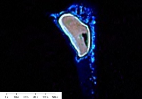
Birnie Atoll - Landsat Image S-02-00_2000 (1:14,000)
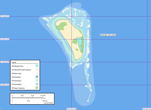
Birnie Atoll - Marplot Map (1:14,000)
Birnie Island (3˚35'S., 171˚31'W.) lies about 43 miles S of the S extremity of Canton Island. The island is 3.6m high on the rim, sloping gradually to sea level at a shallow brackish pond located about 90m inland from the E side of the island. Birnie Island is a bird sanctuary.
A flat fringing reef, drying at LW and extending as far as 0.1 mile offshore, surrounds the island. A shoal, which breaks in heavy weather, extends 0.7 mile S from the S point of the island. A stone monument on the E side of the island, about midway of the length, is visible 6 miles and is a radar target for the same distance.
Tides—Currents.—Close into the W shore the current sets N. Farther off, the set is W and is usually at a rate of about 0.5 knot, with the strength and direction varying with the surface currents set up by the prevailing wind.
Anchorage.—Anchorage is possible about 0.3 mile off the NW point, in 16.5m, with E winds. The S spit is considered too dangerous for anchorage, as it drops off from a depth of 3.7m to 54.9m within 90m. (SD Pub-126)
This map was quickly constructed (2-hours). However I came up with two new layers - EVS Brackish Water (which describes brackish water lagoons that are fed through percolation of sea water) and EVS Uplifted Reef & Scrub Vegetation (which describes island surfaces that have tufts of vegetation and little sand). The image file was taken from Landsat ETM+. I got spoiled on my last island (Nikumaroro Atoll) working from Ikonos imagery. 1-meter imagery is sweet!
Enjoy!
Labels: atoll, EVS, island, Kiribati, Landsat, map, Marplot, Pacific, Phoenix Islands
posted by Mr Minton at 11:20 AM
![]()


0 Comments:
Post a Comment
<< Home