Canton Atoll KR
Wednesday, December 27, 2006
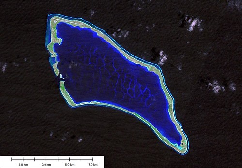
Canton Atoll - Landsat Image S-02-00_2000 (1:75,000)
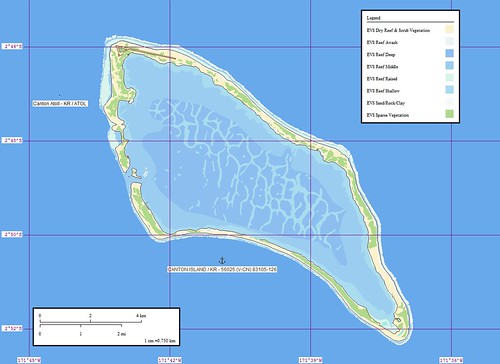
Canton Atoll - Marplot Map (1:75,000)
This is my best map yet! I created a new reef layer (EVS Reef Middle) and then digitized all of the complex reef patterns within the island's lagoon. The colors are outstanding. The island does not have much visible vegetation. There are approximately 80-some people living on the island. Their existence must be very tenuous as the island is subject to prolong droughts.
Canton Island (2˚50'S., 171˚43'W.) (World Port Index No. 56025) is located about 35 miles WNW of the NW extremity of Enderbury Island. It is a coral atoll, enclosing a large lagoon studded with coral heads, and crossed by numerous barrier reefs. As an atoll, it is unique in that the land rim is unbroken except for two openings on the W side. The surf breaks on the N extremity; off the S extremity, heavy tide-rips extend about 0.5 mile from the weather side of the island. The lagoon is infested with shark, moray eel, and ray.
Winds—Weather.—The prevailing winds 90 per cent of the year are E, ranging from ENE to ESE, with an average velocity of 12 to 15 knots and moderate seas. High winds, 25 to 30 knots, and rough seas are infrequently experienced during the months of April, May, and June. During heavy weather, vessels have been held up from entering or leaving the harbor for periods of 2 to 3 days, occasionally extending to 5 days. There are no noticeable seasons throughout the year. Temperatures range from a night low of 24˚C to a daytime high of 35˚C.
Tides—Currents.—Close to the W shore the flood sets 325˚. In the lagoon entrance, the current runs 6 to 8 knots at the strength of the flood and the ebb. The current has been observed to run as high as 11 knots at the ebb, with a strong E wind blowing. Ebb currents produce a marked rip when mixing with ocean currents up to 1 mile or more off the entrance channel. The ocean current near the island sets about 255˚ at about 0.8 knot, but is much stronger at the NW and SE points of the is-land. A vessel lying off the W shore may expect to be set off at the average rate. Local weather conditions make both tide and current predictions inaccurate, and vessels entering the harbor should contact local authorities for information regarding conditions at time of entering.
Depths—Limitations.—The channel had a controlling depth of 7.6m, but in 1988, the channel was reported to have a least depth of 9.1m. Depths of 4.5m were reported immediately outside the channel. Shoaling, which was visible in daylight, was occurring on the Spam Island side of the passage.
Anchorage.—There is fair anchorage on the coral shelf just off the lagoon entrance for vessels drawing less than 7m, in charted depths of 13 to 25m, white coral sand, good holding ground. Care must be taken to insure the vessel anchors on the shelf, as the depth increases abruptly to depths over 30m a short distance seaward. At this anchorage the ship will swing from 040˚ to 160˚, but will not swing into the beach while the trade winds are blowing. West winds are practically unknown at this island. Local opinion, supported by that of masters who have visited the island, is that there is no good anchorage for a vessel too large to enter the harbor. Smaller vessels, waiting for slack water, are advised to stand offshore.
Directions.—A vessel entering the lagoon in 1988 recommended favoring the NW side of the channel, however, bank suction should be guarded against. The pier face was reported to be in good shape, but the bollards were in poor condition. The depth alongside the pier was not stated. It is recommended that vessels berth starboard side-to.
Caution.—The strong current, strong wind, and small space in which to maneuver a fairly large vessel make entry quite hazardous. A speed of 5 to 8 knots must be maintained to stem an ebbing tide in the channel, and to navigate the turn at the lagoon end of the channel. The current in this channel runs as high as 10 knots on both flood and ebb, and the periods of slack water are almost negligible. The channel is on the lee side of the island, and a strong wind may prolong the period of ebb and shorten the period of flood tides. Vessels should plan to enter during daytime at HWS and leave at LWS in order to insure that they will be stemming the current. Also, a boat should be sent close inshore to sound the passage, observe the tidal currents, and to report when conditions are suitable for the vessel to proceed. An explosives dumping area has been established SW of Canton Island, between 3˚09'S and 3˚28'S, and between 171˚53'W and 172˚13'W. (SD Pub-126)
Enjoy!
Labels: atoll, EVS, island, Kiribati, Landsat, map, Marplot, Pacific, Phoenix Islands
posted by Mr Minton at 11:04 AM
![]()


0 Comments:
Post a Comment
<< Home