Tureia Atoll FP
Wednesday, December 27, 2006
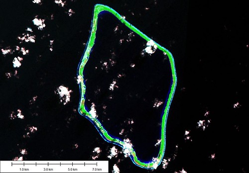
Tureia Atoll - Landsat Image S-07-20_2000 (1:75,000)
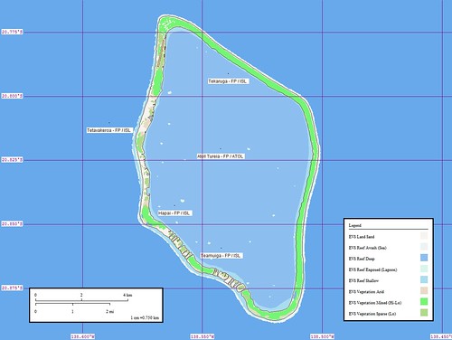
Tureia Atoll - Marplot Map (1:75,000)
Tureia Atoll (20˚49'S., 138˚32'W.) 7 miles long and 5.5 mile wide, is low and wooded except on the SE side; the lagoon is not accessible. Landing at the village on the N side is dangerous and requires the use of a surf boat. (SD Pub-126)
This small atoll in the southern Tuamotu Archipelago is located at 20°50’ south latitude by 138°33’ west longitude. It covers an area of 8.3 square kilometers (3.2 sq. miles). Tureia Atoll is 115 kilometers (71.5 miles) from the atoll of Moruroa and 1,190 kilometers (739 miles) from Papeete. This diamond-shaped atoll is a maximum length of 13 kilometers (8.1 miles) and a maximum width of 7.4 kilometers (4.6 miles). It covers an area of 4,721 hectares (11,665 acres). There is no pass through the surrounding coral reef. The biggest islet, or motu, is located along the northwest coast and measures 22.5 kilometers (14 miles) long by and 250 meters (820 ft.) wide, running from the east coast to the south coast. There also are 27 small motu along the east coast with a total land area of 835 hectares (2,063 acres).
British Captain Edward Edwards, who was looking for the famous “HMS Bounty” mutineers, was the first European to discover Tureia in 1791. This atoll is the administrative center for a district with a population of 1,321 persons (1996 census). A full meteorological station began operation here since 1967, going automatic within the weather station network in June 1987. The station began measuring rainfall in January 1990, an operation that ended in March 1996 with its closing down.
A road from the village of Hakamaru to the north circles the atoll as far as the south. Other roads provide access to the coconut tree plantation, an aerodrome south of the village and a former Pacific Nuclear Testing Center camp made up of 20 facilities, including shelters and several water tanks, all of which have since been abandoned by the French Army.
Information from Presidency of French Polynesia
This is a redo of a very early effort. My first attempt was completed over 2 years ago. I deleted it as I was developing this version. Using Landsat imagery is great for constructing shoreline details resolved to a certain level (+/- 14.5 meters). However, the determination of type of vetation groundcover is tricky at best. One really needs to personally view the island's flora to make an accurate determination. What a job!
Enjoy!
Labels: atoll, EVS, Global Mapper, island, Landsat, map, Marplot, Pacific, Polynesia, Tuamotus
posted by Mr Minton at 10:43 AM
![]()


0 Comments:
Post a Comment
<< Home