McKean Atoll KR

Wednesday, December 27, 2006

McKean Atoll - Image

McKean Atoll - Landsat Image S-01-00_2000 (1:10,200)


McKean Atoll - Map

McKean Atoll - Marplot Map ()1:10,200)


McKean Island (3˚36'S., 174˚08'W.) is a treeless coral island, nearly 0.5 mile round in shape, set on a heart-shaped reef. Breakers extend about 0.3 mile from the N end and 0.2 mile from the S end of the island. The most conspicuous object on the island is the ruin of a large building on the W side, with a coral slab, 2.1m high. Scattered about are the ruins of several structures, obviously part of the old guano works. The island is a wildlife sanctuary.

Winds—Weather.—The winds are nearly always E, varying from NE to ESE, with the former predominating.

Tides—Currents.—The current sets strongly past the N and S points, converging on the W side of the island. Close in to the shore on the W side, the flood sets N and the ebb S. Offshore, the set is W with an average velocity of 0.5 knot, but varying in strength and direction with the prevailing wind. (SD Pub 126)


I mapped this island because of a reference to it in the Atoll Research Bulletin. This map took about 1 hour to complete and post. It's lagoon is classified as a EVS Wetland, because I don't have an appropriate layer designation yet for a lagoon of this nature. It is mostly full of salt tolerant vegetation and rubble. At high tide the lagoon has ocean water percolate into it. Atoll Research Bulletin 228 contain some interesting information about a brief scientific expedition to the island back in 1968. The information is still relevant.

Enjoy!

Labels: , , , , , , , ,

posted by Mr Minton at 11:22 AM 0 comments

Birnie Atoll KR

Birnie Atoll - Image

Birnie Atoll - Landsat Image S-02-00_2000 (1:14,000)


Birnie Atoll - Map

Birnie Atoll - Marplot Map (1:14,000)


Birnie Island (3˚35'S., 171˚31'W.) lies about 43 miles S of the S extremity of Canton Island. The island is 3.6m high on the rim, sloping gradually to sea level at a shallow brackish pond located about 90m inland from the E side of the island. Birnie Island is a bird sanctuary.
A flat fringing reef, drying at LW and extending as far as 0.1 mile offshore, surrounds the island. A shoal, which breaks in heavy weather, extends 0.7 mile S from the S point of the island. A stone monument on the E side of the island, about midway of the length, is visible 6 miles and is a radar target for the same distance.

Tides—Currents.—Close into the W shore the current sets N. Farther off, the set is W and is usually at a rate of about 0.5 knot, with the strength and direction varying with the surface currents set up by the prevailing wind.

Anchorage.—Anchorage is possible about 0.3 mile off the NW point, in 16.5m, with E winds. The S spit is considered too dangerous for anchorage, as it drops off from a depth of 3.7m to 54.9m within 90m. (SD Pub-126)


This map was quickly constructed (2-hours). However I came up with two new layers - EVS Brackish Water (which describes brackish water lagoons that are fed through percolation of sea water) and EVS Uplifted Reef & Scrub Vegetation (which describes island surfaces that have tufts of vegetation and little sand). The image file was taken from Landsat ETM+. I got spoiled on my last island (Nikumaroro Atoll) working from Ikonos imagery. 1-meter imagery is sweet!

Enjoy!

Labels: , , , , , , , ,

posted by Mr Minton at 11:20 AM 0 comments

Enderbury Atoll KR

Enderbury Atoll - Image

Enderbury Atoll - Landsat Image S-02-00_2000 (1:31,250)


Enderbury Atoll - Map

Enderbury Atoll - Marplot Map (1:31,250)


Enderbury Island (3˚08'S., 171˚05'W.) is a coral island consisting of a rim averaging 3.9m high, with a sunken central plain about 1.2m above sea level. The island is steep-to, with a very short reef which makes landing difficult because of the strong sweep of the undertow on the shelving shore. The shelf extends only about 68.5m and drops off rapidly except at the N and SE corners.

Winds—Weather.—The winds vary from the NE to SE. There are frequent, but usually brief rain squalls and they cannot be depended on as the sole water supply.

Tides—Currents.—Immediately W of the island, the current sets to the S with a strength of about 1 knot. In very strong flood tides this set may be reversed. Clear of the island, to the N or S, the average set is about 0.8 knot in a 255˚ direction.

Aspect.—A mast, marked by red obstruction lights, exists about 0.8 mile S of the N extremity. The most conspicuous objects on the island are several palms at the N end; a large guano heap, about 6.1m high on the W side; and the buildings of the settlement at the S part of the island.

Anchorage.—During the season of the Southeast Trades, there is opportunity to anchor on the spit off the NE point, in depths of 45 to 55m, coral and sand. The anchorage should be approached slowly from the WNW with constant use of the depth sounder, as the spit is very narrow and may be overrun easily. The observed set of the current at this anchorage is to the NW, which keeps the stern away from the shore. Anchorage here is not recommended when the Northeast Trades are blowing.

Directions.—The landing place is on the W side of the island, just N of the settlement. Ships may approach the island to within less than 0.8 mile at this point. Landing may be affected by a surfboat through a channel in the reef leading in on a range of two beacons, in line bearing 092˚. Great care must be used in landing as the reef is short and steep, and the channel is narrow with rapid shoaling toward the landing. The best landing conditions prevail at HW and with a strong E wind, which flattens the swell that usually sets in from the S. (SD Pub-126)


This project was relatively fast (2-hours). I am having fun working on these little islands. They are relatively uncomplicated. Most of them are Bird Sanctuaries and are Protected Areas that require approval before you can land. People tried to mine a low-grade of guano for a few years. Now the island is home to birds and feral cats.

Enjoy!

Labels: , , , , , , , ,

posted by Mr Minton at 11:17 AM 0 comments

Manra Atoll KR

Manra Atoll - Image

Manra Atoll - Landsat Image S-02-00_2000 (1:31,250)


Manra Atoll - Map

Manra Atoll - Marplot Map (1:31,250)


span style="font-weight: bold;">Manra Atoll (Sydney Island) (4˚27'S., 171˚15'W.) is a triangular atoll located about 54 miles SSE of Birnie Island. The land rim of the atoll is about 4.6m high, and is covered with brush and trees entirely enclosing a circular lagoon. The island has been reported to give good radar returns up to 7 miles.

Winds—Weather.—The winds at Manra Atoll are almost always E, those of the SE quadrant predominates.

Tides—Currents.—Off the island, the set is W at a rate of about 0.5 knot, varying in strength and direction with the prevailing wind. Close inshore it conforms to the shoreline, diverging at the E extremity and converging at the W extremity.

Aspect.—With a NW wind blowing or at LW, it is better to land on the S side just E of the island. At this point, there is a fissure in the reef wide enough for a boat to enter if properly handled. The passages were reported improved by blasting.

Anchorage.—There is anchorage off the W side of the island, in about 16.5m, about 0.1 mile off the reef sheltered from the prevailing winds. From November to April, NW winds may be expected replacing the prevailing E winds. (SD Pub-126)


Again, this project was fast due to the small size of the island. The lagoon was somewhat complicated. However, the method to complete was steady efforts. I probably spent a total of 2-hours on this map, along with the posting.

Enjoy!

Labels: , , , , , , , ,

posted by Mr Minton at 11:13 AM 0 comments

Orona Atoll KR

Orona Atoll - Image

Orona Atoll - Landsat Image S-02-00_2000 (1:50,000)


Orona Atoll - Map

Orona Atoll - Marplot Map (1:50,000)


Orona Atoll (Hull Island) (4˚30'S., 172˚10'W.) is a coral atoll surrounded by a flat fringing reef, which dries in patches and is about 270m wide. The shelf drops off quickly except at the E extremity, where there is a least depth of 110m, 0.4 mile offshore. At all other points, the 200m curve is within 0.3 mile of the atoll.

The land rim of the atoll is about 0.3 mile wide and encloses a large and relatively clear lagoon. On the SE side of the atoll there are some passes from the lagoon to the outer reef which are fairly deep at HW, but there is no communicating channel through the reef. It was reported that the passes in the reef were improved by blasting.

At the W end of the atoll there are coconut palms from 12 to 18m high; the remainder of the atoll is covered with palm trees and brush, 6 to 12m high. There is a village in ruins on the W part of the atoll.

The lagoon has depths up to 14.6m and 16.5m in places, but it is foul, with numerous shoal coral heads. The larger and shallower heads have been marked with buoyed gasoline drums.

Tides—Currents.—Close into the shore, the current sets W along the atoll with an average velocity of 1 knot. Offshore, the set is W about 0.5 knot, varying with the surface currents set up by the wind. The tidal current in the blasted channel through the reef in the NE part of the atoll is very strong, ranging up to 5 knots.

The E channel, the widest and deepest, carries about 0.9m of water at the spring tides. A channel has been blasted through the W extremity of the reef.


Anchorage.—There is anchorage for small vessels in E winds only, in a depth of about 18.3m, about 0.1 mile off the W extremity of the reef. It is recommended that vessels with a draft of more than 6.1m lie off the W end of the atoll. (SD Pub-126)


The digitizing of this atoll was completed over a period of 2-days. The map took about 6-hours to complete. It took 3 seperate sessions to complete this project. The final session was from 3 to 6 in the morning. When you get started on a project it is tough to stop.

Enjoy!

Labels: , , , , , , , ,

posted by Mr Minton at 11:10 AM 0 comments

Nikumaroro Atoll KR

Nikumaroro Atoll KR

Nikumaroro Atoll (Gardner Island) (4˚40'S., 174˚31'W.) is a wooded, wedge-shaped atoll lying about 137 miles W of Orona Atoll (Hull Island). The atoll is surrounded by a fringing reef, which dries at LW, extending about 0.2 mile offshore. The NW and SE extremities of the reef appears to be extending. Depths off the atoll, which is steep-to except at its NW and SE extremities, average 366m, 0.3 mile from the reef. Nikumaroro Atoll (Gardner Island) encloses a lagoon into which there is no navigable passage. With the exception of two breaks, a large one on the W side and a narrow one on the S side, the land rim of the atoll entirely surrounds the lagoon.

The lagoon is encumbered with coral heads, but seaplanes have landed successfully.

A conspicuous stranded wreck lies close W of the N extremity of the atoll. The wreck was reportedly breaking up.

Tides—Currents.—Off the atoll the set is W, and varies in direction and strength with the prevailing wind. Close inshore, the current follows the trend of the land to the W. There is a deserted village on the W side of the atoll, about 1 mile S of the N extremity, off which anchorage may be obtained by small vessels, very close inshore. Two small beacons N of the village indicate the approach.

Directions.—The best landing place, marked by a white pyramidal concrete structure, is about 0.3 mile S of the village. A boat channel has been cut through the reef in a 054˚ direction and in line with the concrete beacon. Landing should be attempted just after HW when there is less surf than on a rising tide. With a SE wind, landing can be effected in the lee of the wreck at any stage of the tide. The reef is extremely slippery and wide, and the landing is not recommended if any equipment is to be landed or brought off. (SD Pub-126)


This is a redo of a previous post dated 2/25/2006. I wanted to bring in my current colors and include the standard images and maps (1:200,000, 1:100,000, 1:50,000 and 1:25,000). In addition, I wanted to show the Ikonos image that was used to help in digitizing the vectors that makeup this map.

If you have difficulties reading the Flash presentation, go directly to my Flickr account and check out the set of images with the same name as the title of this post.

Enjoy!

Labels: , , , , , , , , , , ,

posted by Mr Minton at 11:07 AM 0 comments

Canton Atoll KR

Canton Atoll - Image

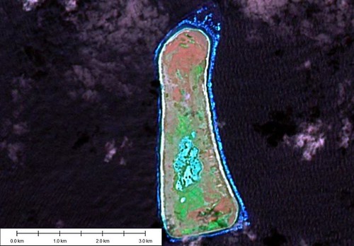
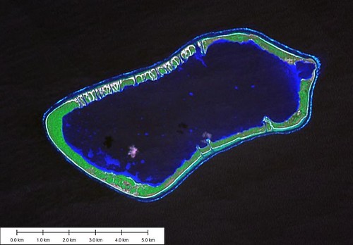
Canton Atoll - Landsat Image S-02-00_2000 (1:75,000)


Canton Atoll - Map

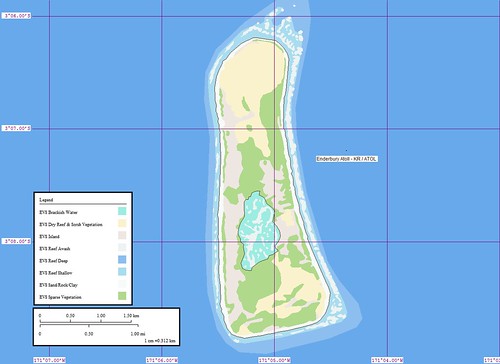
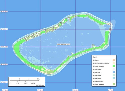
Canton Atoll - Marplot Map (1:75,000)


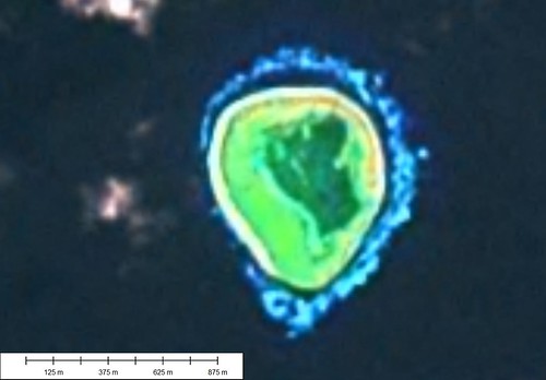
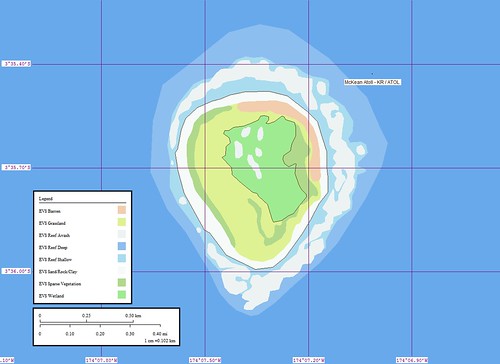
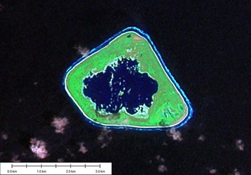
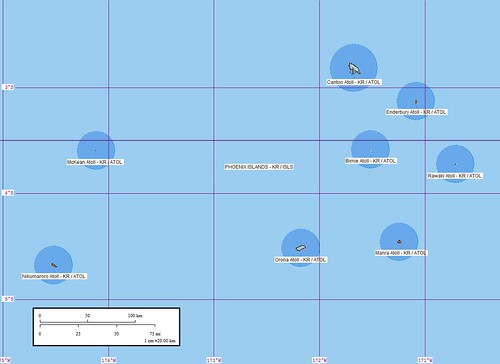
This is my best map yet! I created a new reef layer (EVS Reef Middle) and then digitized all of the complex reef patterns within the island's lagoon. The colors are outstanding. The island does not have much visible vegetation. There are approximately 80-some people living on the island. Their existence must be very tenuous as the island is subject to prolong droughts.

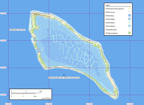
Canton Island (2˚50'S., 171˚43'W.) (World Port Index No. 56025) is located about 35 miles WNW of the NW extremity of Enderbury Island. It is a coral atoll, enclosing a large lagoon studded with coral heads, and crossed by numerous barrier reefs. As an atoll, it is unique in that the land rim is unbroken except for two openings on the W side. The surf breaks on the N extremity; off the S extremity, heavy tide-rips extend about 0.5 mile from the weather side of the island. The lagoon is infested with shark, moray eel, and ray.

Winds—Weather.—The prevailing winds 90 per cent of the year are E, ranging from ENE to ESE, with an average velocity of 12 to 15 knots and moderate seas. High winds, 25 to 30 knots, and rough seas are infrequently experienced during the months of April, May, and June. During heavy weather, vessels have been held up from entering or leaving the harbor for periods of 2 to 3 days, occasionally extending to 5 days. There are no noticeable seasons throughout the year. Temperatures range from a night low of 24˚C to a daytime high of 35˚C.

Tides—Currents.—Close to the W shore the flood sets 325˚. In the lagoon entrance, the current runs 6 to 8 knots at the strength of the flood and the ebb. The current has been observed to run as high as 11 knots at the ebb, with a strong E wind blowing. Ebb currents produce a marked rip when mixing with ocean currents up to 1 mile or more off the entrance channel. The ocean current near the island sets about 255˚ at about 0.8 knot, but is much stronger at the NW and SE points of the is-land. A vessel lying off the W shore may expect to be set off at the average rate. Local weather conditions make both tide and current predictions inaccurate, and vessels entering the harbor should contact local authorities for information regarding conditions at time of entering.

Depths—Limitations.—The channel had a controlling depth of 7.6m, but in 1988, the channel was reported to have a least depth of 9.1m. Depths of 4.5m were reported immediately outside the channel. Shoaling, which was visible in daylight, was occurring on the Spam Island side of the passage.

Anchorage.—There is fair anchorage on the coral shelf just off the lagoon entrance for vessels drawing less than 7m, in charted depths of 13 to 25m, white coral sand, good holding ground. Care must be taken to insure the vessel anchors on the shelf, as the depth increases abruptly to depths over 30m a short distance seaward. At this anchorage the ship will swing from 040˚ to 160˚, but will not swing into the beach while the trade winds are blowing. West winds are practically unknown at this island. Local opinion, supported by that of masters who have visited the island, is that there is no good anchorage for a vessel too large to enter the harbor. Smaller vessels, waiting for slack water, are advised to stand offshore.

Directions.—A vessel entering the lagoon in 1988 recommended favoring the NW side of the channel, however, bank suction should be guarded against. The pier face was reported to be in good shape, but the bollards were in poor condition. The depth alongside the pier was not stated. It is recommended that vessels berth starboard side-to.

Caution.—The strong current, strong wind, and small space in which to maneuver a fairly large vessel make entry quite hazardous. A speed of 5 to 8 knots must be maintained to stem an ebbing tide in the channel, and to navigate the turn at the lagoon end of the channel. The current in this channel runs as high as 10 knots on both flood and ebb, and the periods of slack water are almost negligible. The channel is on the lee side of the island, and a strong wind may prolong the period of ebb and shorten the period of flood tides. Vessels should plan to enter during daytime at HWS and leave at LWS in order to insure that they will be stemming the current. Also, a boat should be sent close inshore to sound the passage, observe the tidal currents, and to report when conditions are suitable for the vessel to proceed. An explosives dumping area has been established SW of Canton Island, between 3˚09'S and 3˚28'S, and between 171˚53'W and 172˚13'W. (SD Pub-126)

Enjoy!

Labels: , , , , , , , ,

posted by Mr Minton at 11:04 AM 0 comments

Phoenix Islands KR

Phoenix Islands - Map

Phoenix Islands - Marplot Map


With the completion of Canton Atoll, my mapping journey through the Phoenix Islands is finished. The first map was McKean Atoll and then seven others followed, with Canton Atoll being the final map. It was fun working on them. They represent some of my best work yet.


I spent the entire month of Februrary 2006 completing this group of 8-islands. Since I have so many new visitors, I thought you might enjoy traveling through this group of interesting Pacific island.

Enjoy!

Labels: , , , , , , ,

posted by Mr Minton at 11:02 AM 0 comments