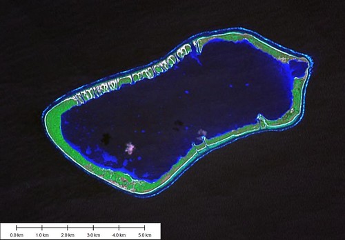
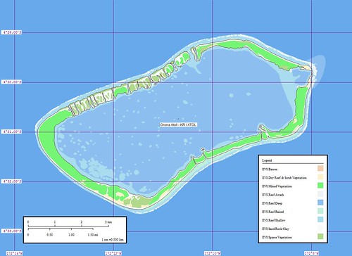
Orona Atoll KR
Wednesday, December 27, 2006
Orona Atoll (Hull Island) (4˚30'S., 172˚10'W.) is a coral atoll surrounded by a flat fringing reef, which dries in patches and is about 270m wide. The shelf drops off quickly except at the E extremity, where there is a least depth of 110m, 0.4 mile offshore. At all other points, the 200m curve is within 0.3 mile of the atoll.
The land rim of the atoll is about 0.3 mile wide and encloses a large and relatively clear lagoon. On the SE side of the atoll there are some passes from the lagoon to the outer reef which are fairly deep at HW, but there is no communicating channel through the reef. It was reported that the passes in the reef were improved by blasting.
At the W end of the atoll there are coconut palms from 12 to 18m high; the remainder of the atoll is covered with palm trees and brush, 6 to 12m high. There is a village in ruins on the W part of the atoll.
The lagoon has depths up to 14.6m and 16.5m in places, but it is foul, with numerous shoal coral heads. The larger and shallower heads have been marked with buoyed gasoline drums.
Tides—Currents.—Close into the shore, the current sets W along the atoll with an average velocity of 1 knot. Offshore, the set is W about 0.5 knot, varying with the surface currents set up by the wind. The tidal current in the blasted channel through the reef in the NE part of the atoll is very strong, ranging up to 5 knots.
The E channel, the widest and deepest, carries about 0.9m of water at the spring tides. A channel has been blasted through the W extremity of the reef.
Anchorage.—There is anchorage for small vessels in E winds only, in a depth of about 18.3m, about 0.1 mile off the W extremity of the reef. It is recommended that vessels with a draft of more than 6.1m lie off the W end of the atoll. (SD Pub-126)
The digitizing of this atoll was completed over a period of 2-days. The map took about 6-hours to complete. It took 3 seperate sessions to complete this project. The final session was from 3 to 6 in the morning. When you get started on a project it is tough to stop.
Enjoy!
Labels: atoll, EVS, island, Kiribati, Landsat, map, Marplot, Pacific, Phoenix Islands
posted by Mr Minton at 11:10 AM
![]()


0 Comments:
Post a Comment
<< Home