Nukutavake Island FP
Wednesday, December 27, 2006
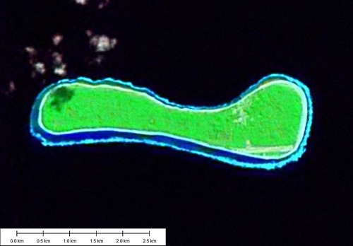
Nukutavake Island - Landsat Image S-07-15_2000
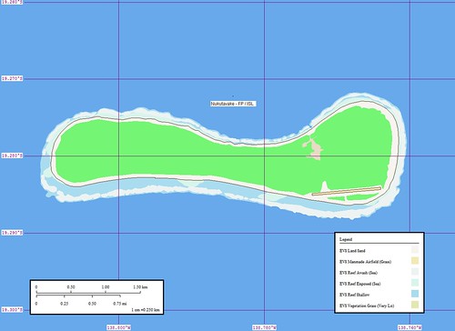
Nukutavake Island - Marplot Map
Nukutavake Island (Noukoutawake) is a small island, of coral formation, located about 8 miles NW of Pinaki. It is about 3 miles long in an E-W direction, and is wooded except at its E end. There is a radio station on the island.
In May, June, and July the population of this atoll moves to Vairaatea, and in August, to Pinaki to harvest copra. (SD Pub-126)
Group: Centre East Group
Archipelago: Tuamotu Archipelago
Country: France - French Polynesia - Tuamotu Is.
Region: Oceania 18
Lat: 19.28º S Long : 138.78º W
Area: 4.5 sq. km
Altitude: ? m
Depth to nearest land: 3000 m
Nearest island: 14.5 km @ 143° (Atoll Pinaki)
Group: 980 km
Nearest continent: South America
Distance: 5400 km Isolation Index: 108
ISLAND TYPE: low coral Natural Protection Indicator: 2
CLIMATE: tropical
CATASTROPHIC THREATS: cyclones Threat Indicator: 1
ECOSYSTEMS: Coconuts; fringing reef Number of Ecosystems - Terrestrial: 1 Marine: 1
Percent shoreline: Coral Reef: 99% Mangrove: 0%
HUMAN OCCUPATION: Uninhabited, ?
Population: 0 Density: 0.0 persons/sq. km
Major Human Activities: coconut plantations
Percent population in agr/mining/fishing: 17% Human Threat Indicator: 1
Gross Domestic Product: $ 7236 per capita Economic Pressure Indicator: 4
DATA RELIABILITY: Data Rel. Indicator: 1
HUMAN IMPACT INDEX HI: 5
CONSERVATION IMPORTANCE INDEX CI-Terrestrial: 5 Low
CI-Marine: 4 Low
Last updated: 27/02/89
Nukutavake (aka Queen Charlotte Island) is an atoll located in the eastern part of the Tuamotu Archipelago at 138°48’ west longitude by 19°17’ south latitude. It is 1,125 kilometers (699 miles) from Papeete. British Captain Samuel Wallis was the first European to discover this atoll in 1767. This is a unique atoll because although it is flat and of coral formation, it has no lagoon. While some accounts claim there are no signs of there ever having been a lagoon, other accounts claim that what was once a lagoon has been entirely filled in by sand and limestone particles from the external coral reef. Part of the atoll is covered by dense vegetation, while the rest has a coconut tree plantation covering some 800 hectares (1,977 acres). Nukutavake is 5.2 kilometers (3.2 miles) long. Its width ranges from 450 meters (1,476 ft.) to 1.3 kilometers (0.81 miles) in the director of the village. The atoll covers an area of 360 hectares (890 acres).
The village, located in the northeastern part of the atoll, has some streets and a main road from the coast and the coconut plantation. There is an aerodrome 800 meters (2,625 ft.) south of the village, linking the atoll to the outside world. There is a whaleboat dock opposite the village that allows for transferring people and cargo from and to cargo ships that anchor offshore. The 1996 census recorded a population of 196 persons. The atoll is the administrative center for a district made up of the associated districts of Vahitahi and Vairaatea.
This island was mapped quickly. Not carelessly, but quickly. It took about 1-hour to digitize and create the map. Another 30-minutes to post and comment.
Also, the discovery of the additional island information from the web site of the President of French Polynesia (what a job!) will enhance the information associated with this island. I did send him an email to present my website. However, no reply as yet.
Enjoy!
Labels: atoll, EVS, Global Mapper, island, Landsat, map, Marplot, Pacific, Polynesia, Tuamotus
posted by Mr Minton at 10:56 AM
![]()


0 Comments:
Post a Comment
<< Home