Enderbury Atoll KR
Wednesday, December 27, 2006
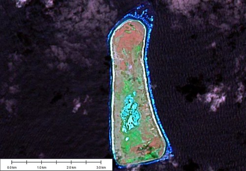
Enderbury Atoll - Landsat Image S-02-00_2000 (1:31,250)
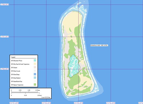
Enderbury Atoll - Marplot Map (1:31,250)
Enderbury Island (3˚08'S., 171˚05'W.) is a coral island consisting of a rim averaging 3.9m high, with a sunken central plain about 1.2m above sea level. The island is steep-to, with a very short reef which makes landing difficult because of the strong sweep of the undertow on the shelving shore. The shelf extends only about 68.5m and drops off rapidly except at the N and SE corners.
Winds—Weather.—The winds vary from the NE to SE. There are frequent, but usually brief rain squalls and they cannot be depended on as the sole water supply.
Tides—Currents.—Immediately W of the island, the current sets to the S with a strength of about 1 knot. In very strong flood tides this set may be reversed. Clear of the island, to the N or S, the average set is about 0.8 knot in a 255˚ direction.
Aspect.—A mast, marked by red obstruction lights, exists about 0.8 mile S of the N extremity. The most conspicuous objects on the island are several palms at the N end; a large guano heap, about 6.1m high on the W side; and the buildings of the settlement at the S part of the island.
Anchorage.—During the season of the Southeast Trades, there is opportunity to anchor on the spit off the NE point, in depths of 45 to 55m, coral and sand. The anchorage should be approached slowly from the WNW with constant use of the depth sounder, as the spit is very narrow and may be overrun easily. The observed set of the current at this anchorage is to the NW, which keeps the stern away from the shore. Anchorage here is not recommended when the Northeast Trades are blowing.
Directions.—The landing place is on the W side of the island, just N of the settlement. Ships may approach the island to within less than 0.8 mile at this point. Landing may be affected by a surfboat through a channel in the reef leading in on a range of two beacons, in line bearing 092˚. Great care must be used in landing as the reef is short and steep, and the channel is narrow with rapid shoaling toward the landing. The best landing conditions prevail at HW and with a strong E wind, which flattens the swell that usually sets in from the S. (SD Pub-126)
This project was relatively fast (2-hours). I am having fun working on these little islands. They are relatively uncomplicated. Most of them are Bird Sanctuaries and are Protected Areas that require approval before you can land. People tried to mine a low-grade of guano for a few years. Now the island is home to birds and feral cats.
Enjoy!
Labels: atoll, EVS, island, Kiribati, Landsat, map, Marplot, Pacific, Phoenix Islands
posted by Mr Minton at 11:17 AM
![]()


0 Comments:
Post a Comment
<< Home