Manra Atoll KR
Wednesday, December 27, 2006
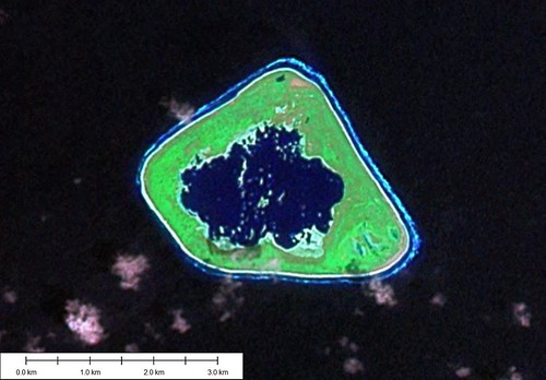
Manra Atoll - Landsat Image S-02-00_2000 (1:31,250)
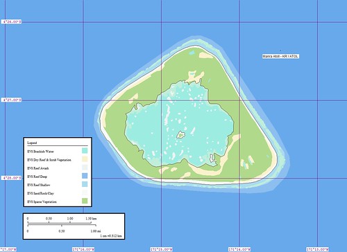
Manra Atoll - Marplot Map (1:31,250)
span style="font-weight: bold;">Manra Atoll (Sydney Island) (4˚27'S., 171˚15'W.) is a triangular atoll located about 54 miles SSE of Birnie Island. The land rim of the atoll is about 4.6m high, and is covered with brush and trees entirely enclosing a circular lagoon. The island has been reported to give good radar returns up to 7 miles.
Winds—Weather.—The winds at Manra Atoll are almost always E, those of the SE quadrant predominates.
Tides—Currents.—Off the island, the set is W at a rate of about 0.5 knot, varying in strength and direction with the prevailing wind. Close inshore it conforms to the shoreline, diverging at the E extremity and converging at the W extremity.
Aspect.—With a NW wind blowing or at LW, it is better to land on the S side just E of the island. At this point, there is a fissure in the reef wide enough for a boat to enter if properly handled. The passages were reported improved by blasting.
Anchorage.—There is anchorage off the W side of the island, in about 16.5m, about 0.1 mile off the reef sheltered from the prevailing winds. From November to April, NW winds may be expected replacing the prevailing E winds. (SD Pub-126)
Again, this project was fast due to the small size of the island. The lagoon was somewhat complicated. However, the method to complete was steady efforts. I probably spent a total of 2-hours on this map, along with the posting.
Enjoy!
Labels: atoll, EVS, island, Kiribati, Landsat, map, Marplot, Pacific, Phoenix Islands
posted by Mr Minton at 11:13 AM
![]()


0 Comments:
Post a Comment
<< Home